Historic properties survey nears finish line in Erving
| Published: 05-30-2025 2:02 PM |
ERVING – Since December, Brian Knight of Brian Knight Research has been visiting residences and cultural locations in Ervingside, Farley and along the major routes of Route 63 and Route 2, and he is now finishing a cultural resources report as part of the town’s Historic Properties Survey project.
The report, which is due Sept. 30, contains information Knight has gathered as part of his survey, and town officials and residents got a firsthand look at this information that will be submitted to the Massachusetts Historical Commission during a presentation on Wednesday.
The project is funded through a $40,000 grant, half of which comes from the Massachusetts Historical Commission. Voters at the May 2023 annual Town Meeting authorized a $20,000 match, and after a year of searching for a contractor, Knight was tapped for the project due to the company’s experience surveying in Greenfield and Orange.
As earlier reported by the Recorder, Knight has been working with the Erving Historical Commission to identify 140 survey locations out of 220 possible sites across Erving, many of which are homes that were built in the late 19th and early 20th centuries.
The locations of interest include residential homes around the former International Paper Mill and the roads surrounding the Renovators Supply Co. complex at 1 River St in the Erving portion of Millers Falls, known to residents as Ervingside. His focus is also in Farley Village, as well as locations along Route 2 heading in both directions.
Town Administrator Bryan Smith said during the May 28 presentation that in the 1980s, the Erving Historical Society provided information to the state on Erving Center, so the work by Knight is filling in the gaps of Erving’s infrastructure. This presentation was a chance for residents to provide feedback and give recommendations to Knight, who has four months to finalize his work before the deadline.
“It’s to preserve the history of the town, and have it live beyond those in town,” he said.
In his presentation, Knight explained his methodology of synthesizing information from site visits, property deeds, newspaper articles, maps, census data and photographs to link together information about the types of properties in Erving, when structures were built and who lived in them, among other bits of information he is uncovering. He’s found that some oldest housing stock in Erving sits along Route 63, and are old agricultural homes that were built in the 1850s — conclusions he reached through his research.
Article continues after...
Yesterday's Most Read Articles
 Mohawk Trail Regional School grads move on to a new beginning
 Greenfield Schools to seek interim superintendent
 Conservation land access dispute heads to mediation in Leverett
 Shutesbury police chief placed on administrative leave until June 30
 ‘We all reached the summit together’: Greenfield High School celebrates 87 graduates
 Div. 6 Track and Field: Frontier’s Ben Cachiguango, Pioneer’s Natalie Rios capture state titles on Day 2
“Combine that all, and you have a clearer view of how a farm operated in the 1850s” Knight said.
In the 1870s during a period of industrialization in Erving, there was a rise in homes in Ervingside as major companies like the Erving Paper Company and Millers Falls Tool Company built housing for their workers, many of which were developed in straight lines and square parcels for single-family homes on streets like . As the town entered the 20th century, more housing and structures were built per property maps, photographs and illustrations revealed.
To Knight, he feels this industrial growth isn’t necessarily unique to Erving, but rather, the way the geography of the town influenced how homes, businesses and other structures were built along the Millers River is what makes the town stand out.
“It's just a very unique land use,” Knight said, explaining how Northfield Mountain and the Millers River create a situation where people settle near where an industry can be created, and in this case, it was along the river.
“Not only the relationship to the river and the mountain dictated where people live, but the river is also a primary source of industry and income for the people of Erving,” he said.
To give an idea of what progress Knight has made so far on the survey, he brought two large binders of forms between 300 and 400 pages long, containing the property information he’s collected thus far. In his experience, he said the information he provides the state will be edited and posted online, adding to the existing information on the Massachusetts Cultural Resource Information System.
Erving Historical Commission Chair Philip Johnson said with this information from Knight, the town will then be able to think about next steps that could include creating a historic district, similar to Millers Falls that was designated a historic district through the National Register of Historic Places in 2021.
“If we want to investigate that, we'll think about that as a commission after we get this whole project wrapped up and accepted,” Johnson said about the possibility of a historic district. “Then we can see what does it take.”
Erin-Leigh Hoffman can be reached at ehoffman@recorder.com or 413-930-4231.
 Voters to decide Prop. 2½ override in Wendell
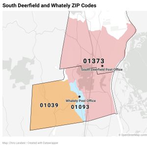 Whately to consolidate ZIP codes on Jan. 1
 Four Rivers Charter Public School grads ready to take flight